


CEDA Maps
140 00 Praha 4-Michle
Czech Republic
Profil
It offers more than just maps, it can plan fast and special routes - for cars, trucks, firefighters or even wheelchair users. It monitors traffic conditions, parking options and even finds the right way to the right platform. Global technology leaders, authorities and businesses rely on it.
CEDA is a recipient of the Visionaries 2021 honorary award and is the representative of Google, TomTom and HERE mapping solutions for the CEE region.
Exhibitor's products
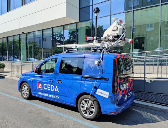
Ultra HD Mobile Mapping Vehicle
It is a special vehicle equipped with one of the most powerful mobile mapping systems in the world.<br /> The car is used to create (Ultra) HD maps, which are essential for autonomous vehicles. It is currently involved, for example, in an autonomous tram project.<br /> The vehicle is equipped with a pair of super-powerful LIDARs, a panoramic camera and a number of HD cameras, twin GNSS antennas, an odometer and a super-precise inertial unit. <br /> In 8 hours of operation, the vehicle collects approximately 10 TB of data (10,000 GB of data). This is so large that it cannot be sent over the internet.<br /> The vehicle also includes a data processing line that contains powerful data storage and software applications with artificial intelligence elements that can automatically locate objects such as trees, poles, girders, etc. in the measured data.<br /> For comparison, imagine how long it takes a surveyor to locate 1 point on a plot of land with an accuracy of 14cm in 2D. A vehicle at 130km/h (even driving on cubes) locates 3.6 million of them per second in 3D and achieves an absolute accuracy of about 3cm under optimal conditions. Thanks to special techniques, even higher accuracy can be achieved and, same time, high accuracy can be maintained even in difficult conditions (e.g. in a tunnel).
07 Automated and autonomous driving and driver assistance systems

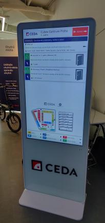
Smart indoor navigation kiosk
The navigation kiosk is used to support navigation in buildings.<br /> Visitor cards for turnstiles are replaced by smart cards that communicate with kiosks located at the corridor intersections, staircases and elevators in the building. When a visitor reports to the front desk the purpose of a visit to the building, the purpose is assigned to a specific visitor card in the system. If the visitor approaches the kiosk with it, a personalized navigation instruction is displayed (it disappears again when the visitor moves away). This allows the system to handle large numbers of visitors even though it has separate instructions for each one.<br /> The navigation instructions are in the form of an arrow, a text instruction (for the blind it can be a voice instruction) and possibly also a video showing the section from the visitor's current position to the next kiosk (so the visitor does not need to know Czech and actually does not need to be able to read)<br /> The kiosks allow the visitor to plan accessible routes and can react to dynamic constraints in the building (non-functioning elevator, closed corridor, etc.). Kiosks have support for mass events (no cards required) and for evacuation.<br /> Other solutions are designed for buildings without controlled access, such as train stations, hospitals, campuses and other types of buildings.
Exhibitor's product categories
Product categorie: 07
Automated and autonomous driving and driver assistance systemsUsing HD mobile mapping systems and processing huge volumes of data using artificial intelligence, we capture reality and convert it into valuable information in the form of passports, digital technical maps or road surface mapping. <br /> With Ultra HD Maps, we enable the deployment and safe operation of autonomous vehicles. We participate and support research and development teams in the field of highly automated and autonomous vehicles.<br /> We use the most advanced mobile mapping technologies globally. We carry out efficient data collection and processing bringing an incredible amount of information for various agendas. We acquire and process imagery and point clouds of the area of interest with < 10 cm accuracy in 3D. We detect the risk of objects colliding with the vehicle or train profile. We evaluate defects on roads.
Product categorie: 08
Connectivity, communication system and digital servicesMaps and APIs for your projects - Maps and APIs from CEDA, Google, HERE or TomTom. We can help you choose a mapping solution for each project and how to get the most out of it with smart maps.<br /> Routes exactly to your needs - Route search by mode of transport will find the best routes to actually take. Save miles, time and the environment.<br /> Smart city travel - Mobility as a service: efficient mobility solutions for cities and regions. Convenient and sustainable transport for the future.<br /> Innovation for the mobility of the future - We follow trends and find ways to use maps, data and smart algorithms to create the smart and green transport of tomorrow.<br /> Outdoor and indoor positioning - Even where GPS can't go, we provide navigation, maps or motion analysis. Outside and for buildings, tunnels or parking lots.<br /> Smart traffic data - We connect sensors, apps, drivers and passengers. Online data on traffic, parking, charging and public transport.<br /> Special turnkey maps - We map your roads, buildings or parking lots accurately and customized. Passports, HD maps, technical maps - we have the solution.
